
Mohican Amish Country Weather
Current Conditions

Mostly Cloudy
68°F
20°C
| Humidity | 81% |
| Wind Speed | N 10 mph |
| Barometer | 29.96 in (1014.0 mb) |
| Dewpoint | 62°F (17°C) |
| Visibility | 10.00 mi |
| Last update | 3 Aug 8:52 am EDT |
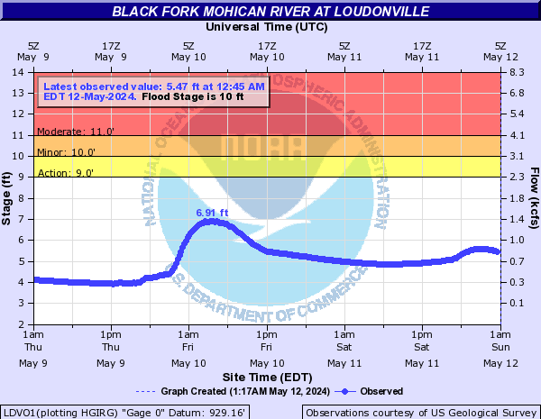
River Conditions
Extended Forecast
Today

High: 77 °F
Becoming
SunnyTonight

Low: 51 °F
Clear
Tuesday

High: 81 °F
Sunny
Tuesday Night

Low: 58 °F
Mostly Clear
Wednesday
High: 84 °F
Mostly Sunny
then Chance
T-stormsWednesday Night
Low: 63 °F
Chance
T-storms then
Chance
ShowersThursday
High: 84 °F
Mostly Sunny
then Chance
T-stormsThursday Night

Low: 64 °F
Chance
T-stormsFriday
High: 82 °F
Chance
T-storms then
Showers
Likely
Detailed Forecast
Today
Partly sunny, then gradually becoming sunny, with a high near 77. North wind around 9 mph.
Tonight
Clear, with a low around 51. North wind around 5 mph becoming calm in the evening.
Tuesday
Sunny, with a high near 81. Calm wind.
Tuesday Night
Mostly clear, with a low around 58. Calm wind.
Wednesday
A chance of showers and thunderstorms after 2pm. Mostly sunny, with a high near 84. Light and variable wind. Chance of precipitation is 50%. New rainfall amounts of less than a tenth of an inch, except higher amounts possible in thunderstorms.
Wednesday Night
A chance of showers and thunderstorms before 2am. Mostly cloudy, with a low around 63. Chance of precipitation is 30%. New rainfall amounts of less than a tenth of an inch, except higher amounts possible in thunderstorms.
Thursday
A chance of showers and thunderstorms after 2pm. Mostly sunny, with a high near 84. Chance of precipitation is 50%.
Thursday Night
A chance of showers and thunderstorms. Mostly cloudy, with a low around 64. Chance of precipitation is 50%.
Friday
A chance of showers and thunderstorms, then showers likely and possibly a thunderstorm after 2pm. Mostly cloudy, with a high near 82. Chance of precipitation is 70%.
Friday Night
Showers likely, mainly before 8pm. Mostly cloudy, with a low around 62. Chance of precipitation is 60%.
Saturday
A chance of showers and thunderstorms. Partly sunny, with a high near 82. Chance of precipitation is 40%.
Saturday Night
A chance of thunderstorms. Partly cloudy, with a low around 63. Chance of precipitation is 30%.
Sunday
A chance of showers and thunderstorms. Mostly sunny, with a high near 84. Chance of precipitation is 30%.
Hourly Forecast
| Date | 08/03 | 08/04 | ||||||||||||||||||||||
| Hour | 9am | 10am | 11am | 12pm | 1pm | 2pm | 3pm | 4pm | 5pm | 6pm | 7pm | 8pm | 9pm | 10pm | 11pm | 12am | 1am | 2am | 3am | 4am | 5am | 6am | 7am | 8am |
| Temperature (°F) | 65 | 68 | 70 | 72 | 74 | 76 | 76 | 77 | 76 | 75 | 74 | 71 | 67 | 65 | 62 | 61 | 59 | 58 | 57 | 55 | 54 | 54 | 53 | 57 |
| Chance of Precipitation | 0 | 0 | 0 | 0 | 0 | 0 | 0 | 0 | 0 | 0 | 0 | 0 | 0 | 0 | 0 | 0 | 0 | 0 | 0 | 0 | 0 | 0 | 0 | 0 |
| Date | 08/05 | |||||||||||||||||||||||
| Hour | 9am | 10am | 11am | 12pm | 1pm | 2pm | 3pm | 4pm | 5pm | 6pm | 7pm | 8pm | 9pm | 10pm | 11pm | 12am | 1am | 2am | 3am | 4am | 5am | 6am | 7am | 8am |
| Temperature (°F) | 62 | 69 | 73 | 75 | 77 | 79 | 80 | 81 | 81 | 80 | 79 | 76 | 71 | 68 | 66 | 65 | 63 | 62 | 61 | 60 | 60 | 60 | 61 | 64 |
| Chance of Precipitation | 0 | 0 | 0 | 0 | 0 | 0 | 0 | 0 | 0 | 0 | 0 | 0 | 0 | 0 | 0 | 0 | 0 | 4 | 4 | 4 | 4 | 4 | 4 | 11 |